Wednesday, August 8, 2012

Nicollet Again & Still; A Word with Council Member Lilligren

Last Friday I had the pleasure and opportunity to interview Robert Lilligren, Minneapolis Ward 6 Council Member who presides over the blight known as the "Sea of Parking" and it's associated K-Mart at the intersection of Nicollet Avenue and Lake Street.

As you walk into Council Member Lilligren's office, one of the first things you'll notice is the list of priorities on his wall.  Scribbled in red on the whiteboard is a large #1, followed by, " Reopen Nicollet".  That note is years old, but today momentum is building and it seems this aspiration may very well come to fruition within the foreseeable future.

Similar to CM Lilligren, this issue has been on my mind quite a bit recently, and I'm here in his office to interview him on where this project sites now, and what we can expect in the near future.

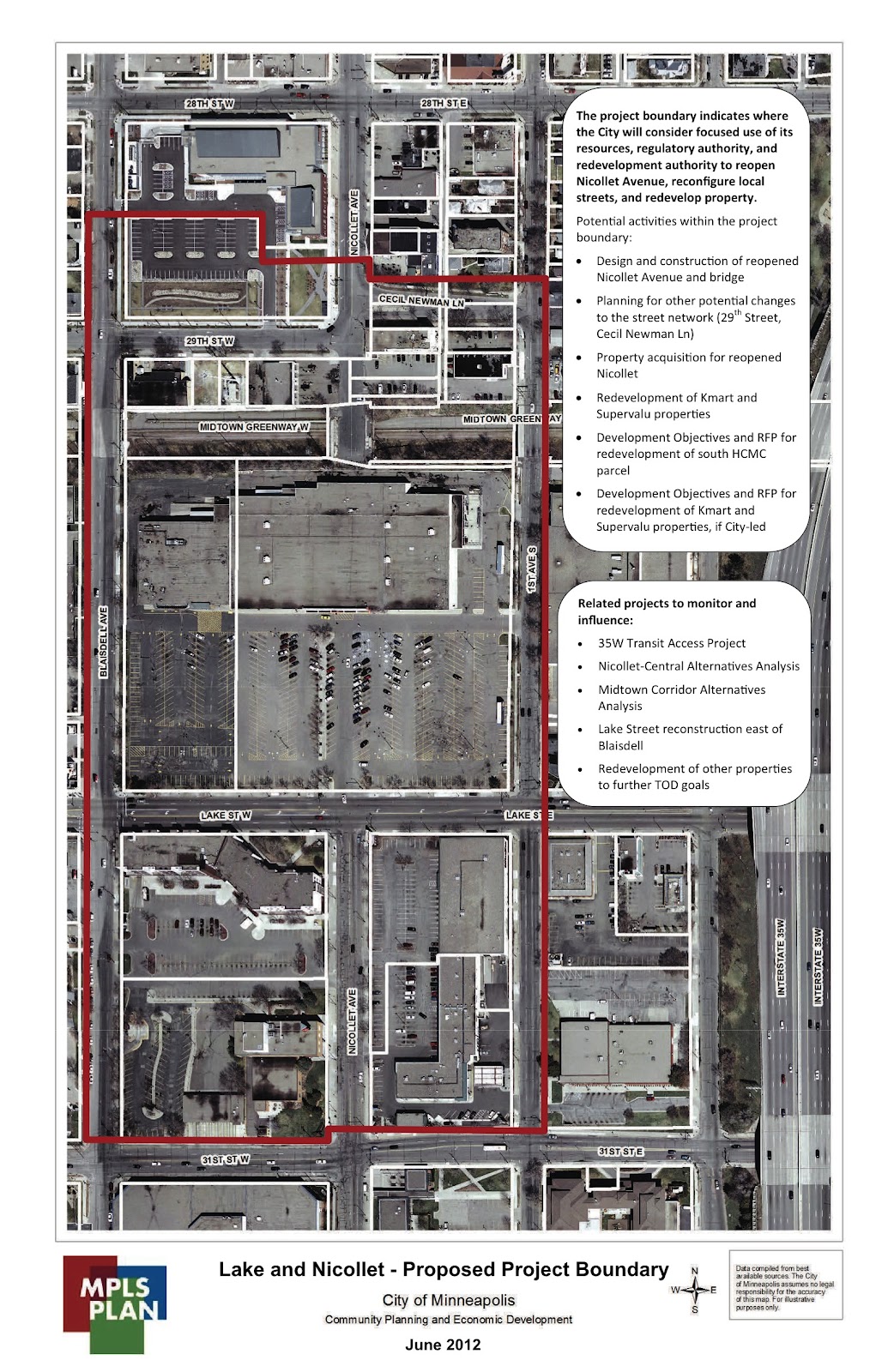
Below is an image from the City of Minneapolis Planning Department outlining the proposed project site (delineated in red).  You'll notice that the proposed bounds of the project site extend well beyond the large contested parcel in the middle (parcels delineated in white), but that's largely because it is always easier to start big and edit down than vice versa.

In the interest of time, the interview was kept short, but with a foundational understanding of the site, I got right to the brass tacks.

You can hear the full edited version of the interview as a Podcast on streets.mn later this week (provided by Mr. Bill Lindeke).

Fir now, those basic points are these: why is this important, what's the big issue, what are the associated issues, and what are the next steps?

The big pitch is that currently K-MArt is a disconnected vacuum in three otherwise thriving corridors.  The most obvious is Nicollet Ave. Ask any conscious citizen of Minneapolis whether they'd like to see this site re-vamped and I will throw my laptop off teh Washington Ave Bridge if they don't say "yes" in one form or another.  Suffice to say that this is a popular subject.

For historical context, Nicollet used to be known as Minneapolis' Main Street, stretching from the river all the way past Minnehaha Parkway.  Now, thanks to poor TIF and site management, we have a huge plug in that system.

The second obvious gap this creates is the string of commercial nodes along Lake Street.  We have some great places there: Hennepin-Lake, Lyn-Lake, the Midtown Exchange, etcetera.  Thanks to the parking and lack of street amenities, the K-Mart site is a huge comparative let-down.

Finally, last but not the least by far, is The Midtown Greenway.  In what other world do you find $10k carbon road machines mixed with all manner of commuters, just feet from both a vibrant restaurant corridor (Eat Street), and a disused ocean of parking, all at the same spot.  It's amazing if you thing about the real proximity; grade-separation at it's worst.

The big, looming issue is site control.  Currently, the K-Mart site is owned by a land trust based in NYC, who has probably never gotten to know the site and who are, as a result, only financially invested in the site.  That is, there is clearly no sense of community stewardship happening here.  According to Mr. Lilligren, discussions are moving forward with the family who constitute the board of trustees to move possession into the hands of a developer who can do better, or into some kind of public-private partnership (warning: TIF may be involved).  One important point that CM Lilligren wanted to stress is that the only workable solution that would manifest would be one with a strong public engagement process.

One of the associated issues, as always, is parking.  Why so much parking?  Why so many minimally required stalls?  In one of my previous posts I noted that this site is a gap in the Pedestrian Overlay District that should extend and intersect Lake and Nicollet, which would lower the parking requirements.  Even with these token deductions though, could we do more?  Mr. Lilligren mentioned briefly that the city planners could someday look to a time when we have (gasp) no minimum parking requirements.  What!?  Yep.  Not a typo.  Think about one of our most vibrant urban places, Dinkytown.  No minimum parking requirements for new developments.  A keen eye will notice that this does not manifest as a total lack of parking, but the amount is relatively small when compared to what is required in other other places around Minneapolis.  This is because the parking is determined by market demand, not by city mandate, and from where I sit it seems to work very well and efficiently.

Finally, where is all this going?  It seems that momentum is building and that there is widespread public support.  Along with the project site bounds, CM Lilligren showed me a schedule that involves a preliminary stakeholder engagement process on August 15th.  Keep your eyes peeled for that.  The schedule also notes City of Minneapolis appropriation of resources for the project on Dec. 1, and hopefully full site control by Jan 1, 2013.  It seems that some good discussions are happening at the city, but talk is cheap.  However, I do feel confident in stating that within my lifetime this may well happen, and if the right people and the community are on-board, it will be an awesome and welcome change.

Monday, June 25, 2012

Nicollet, the Greenway, and K-Mart: A Proposal for Change


We’ve all seen it, and by-in-large, we all loathe it: the K-Mart on Lake Street between Blaisdell and 1st Ave S.   You know, that place where Minneapolis’ main street used to come through.  Last spring I had the opportunity to analyze this site in-depth as my landscape architecture and urban planning capstone project.
At this site, there is a lack of connection across the site both to downtown Minneapolis and along Lake Street, as well as a disconnection from the Midtown Greenway.  After identifying these issues I thought to myself, “I can fix that”; easier said than done.  Because of the complicated nature of any urban landscape, there are a thousand ways to “fix that”, and with only 13 weeks to consider them all, I really only scratched the surface.
However, there are three important and obvious interventions that this site desperately needs.
1: Urbanizing K-Mart to address the street and minimize parking lot frontage.
2: Re-opening Nicollet Ave and re-establishing Lake and Nicollet as a vibrant pedestrian-oriented commercial node.
3: Using the void left by K-Mart to open the Greenway and connect to Lake Street.
You wouldn’t know it from the number of cars in their massive parking lot, but this K-Mart does surprisingly well as a business.  This is largely because of its market niche: it’s the only discount retailer for miles.  For parking, the site has 522 available stalls and is rarely, if ever, over 25% occupied.  Why?  Transit.  The Metro stop at this intersection is consistently one of the busiest in the city.

Daily Bus ridership in 2011, as compared to the adjacent intersections.

If most of the people using the store don’t drive, or more likely, don’t own an automobile, then why have a 300’ set-back for parking that is never used?   The obvious answer is to get rid of it, or at least minimize its presence.
So what does it mean to "urbanize" a sprawling 1-story retail store?  Take the downtown Target store as an example: it constitutes about half of the footprint of K-Mart (~92,000 square-feet), has almost the same amount of retail floor space, no surface parking, and serves many more customers.  So if we assume this is a good idea, what happens to the site?  We can move K-Mart so that it addresses the street and the intersection, and all of a sudden we have plenty of space for, say, a new road!
Enter your new, re-connected, pedestrian-friendly, Nicollet Ave.  In the 70’s, K-Mart was put in place as a block from downtown to prevent urban blight from creeping into the neighborhood, and as a disconnecting block it’s been extremely successful.  Unfortunately, this also means that the neighborhood began to atrophy now that it's cut-off from the economic activity enjoyed by the Nicollet corridor north of 29th St.  It isn’t just the N-S connection that is missing; look at the Pedestrian Overlay District map from the City of Minneapolis.  Lake and Nicollet should be one of a contiguous string of commercial nodes along Lake Street, stretching from the Chain of Lakes to Hiawatha.  It would seem that increasing commercial density, and perhaps introducing mixed-use capacity could help mitigate this issue and help reconnect these two axes.  Additionally, the expansion of this pedestrian overlay district would bring a significant reduction in the amount of minimum required parking stalls.

Midtown Minneapolis Pedestrian Overlay Districts (green) with the current K-Mark site on Lake St (red)


Finally, the Midtown Greenway.  Don’t get me wrong, I love the Greenway, but one significant flaw is connection and wayfinding to the rest of the city.  For most new users on this corridor, there is almost no intuitive way of knowing where you are in relation to the rest of the street grid.  It can be a monotonous jag through the heart of Midtown Minneapolis, punctuated by a bike shop, a soccer field, and one or two gardens.  If you need to get up to a smaller non-arterial avenue, good luck deciphering which hellishly steep ramp to mount.
Just like Lake Street, I would love to see a series of true places along this corridor.  For safety’s sake, I’d like to see more eyes on the street, which means mixed-use development with frontage right down on the trail.  I say mixed-use because that would entail activity 24-hours a day: workers and commerce during the day, residents at night.  Furthermore, if we could peel back the topography of the Greenway into the space left by the urbanization of K-Mart, we could, potentially, make a graceful open-space connection between Lake and the Greenway.  This too, would start to form a legible “place” on the Greenway: a spot that would let you know where you are in relation to what’s above and around you.
A vision of what a place on the Greenway could look like: park space, community gardens, plazas, and ADA accessible ramp connection.
This image shows what a graceful connection from Lake St (left) to the Greenway (green line sloping down to the right) could look like.

A view from a pedestrian promenade facing the open space on the Greenway, this shows where Nicollet could come across, with a potential future streetcar stop at the Greenway with vertical circulation connecting the two.

A more technical section of the streetcar stop, this is meant to demonstrate that while there is automobile circulation, there is more space given to pedestrians and transportation.

Admittedly, the challenges to this type of change are many and varied.  Not least of which is the fact that the City of Minneapolis gave up control of the K-Mart parcels with a decades-long lease to an investment firm in New York.  Also, I understand that many of these proposals come with their own set of issues.  This is unavoidable.  While I don’t purport to have all the practical answers, what I can offer are ideas and vision, and I believe my generation of professionals has an obligation to do just that.  Wish me luck.


Sunday, February 19, 2012

The Manifesto


These graphics finally display what my big ideas and drivers are. It started with an idea of what I have traditionally liked in urban spaces, and some traditional notions of landscape architecture in an urban context.

With some research, I found that the 20th century paradigm of urban organization around the automobile is one of the major reasons that modern cities don't have the charm and appeal that cities used to carry. So, what did we used to do? We used to design for people. So, that's what I propose to do again. As noted on the manifesto graphic, I'm going to take that priority system of automobiles first, and turn it on it's head.

What if, instead of walking being the most inconvenient and uncomfortable mode of urban movement, driving your car was the mode that was least desirable? How would that manifest, and what would it look like? These are the big questions.

A few ideas on the ground


Over the last week or so I've been sorting out what, exactly, I'm doing. Previously I've had some amorphous ideas about neat spaces, but no drivers, editing devices, or succinct encapsulation of what this project is all about.

These are a couple images of preliminary ideas, and a map of green spaces in mid-south Minneapolis. In the sketch, the bulbous vertical piece is a quick sketch of what could happen with Nicollet Ave at the Greenway. Perhaps a cafe, and/or some vertical circulation?

Tuesday, January 31, 2012

Collage!


As an artistic interpretation of my site, over the last couple days, I've assembled a collage of the site elements I'd like to see in my final project, and overlay-ed those images on a simplified topographic model of my site. This is more artistic than I usually get with these sorts of things, but I think there's some experiential understanding to be gained.

Also, it's nice to have time to pursue these crazy ideas while I'm in grad school, because I'm sure no employer or client is going to want to pay em for time in which I simply cut out magazine images and glue them to chipboard.

Scenarios

Over the course of last week, our professors put us to the task of outlining two scenarios, and fleshing them out to see what different sets of circumstances would lead to. Fro me, one of the most challenging aspects of this mental experiment were to come up with two significantly divergent scenarios in the first place.

I know a lot about my site, and I know a lot about the recent history that has made it the depressing landscape that it is, but how do I look at those vast areas of parking, financial depressed businesses, strip-mall outlets and fast food stores to imagine futures that are bright and promising? It took a lot of reading, writing and thinking, in cyclical iterations.

The scenarios, obviously, are simply a means to an end. To look at different futures and what they entail, then take the best design elements from each and work with those towards a project that is more realistic in the end.

My two scenarios were entitled Alpine Style and Amnesty+. In the former, energy access has become scarce, and cities/neighborhoods need to become as self-reliant and efficient as possible. In the latter, I envisioned a world where the federal government made allowances for amnesty of current illegal citizens, and created a legal guest-worker program. According to research, this would result in a population surge in my capstone area of almost 400,000 people over the highest current population projections.

These scenarios pulled me through a handful of design ideas that included using the space underneath 35W as a kind of parking ramp, and changing the streetscape to take full advantage of solar gain.

Given the short amount of time that we were working on this kick-off design push, there isn't much in the body of work I created that I hold too much stake in, but it started the process, and that is likely the most important outcome. To be sure, the first set of ideas that I generate in any design process are absolute garbage, but often there are some pieces that I can carry forward, and this was that stage in my capstone process.

Buildings!


...and here we have some photos of the building masses on-site. So many hours at the lazer-cutter and gluing table...

Friday, January 20, 2012

Topo

Today, done with topographic modeling. Up next, buildings. Then maybe we'll think about a highway...

Tuesday, January 17, 2012

The Modeling Begins

First, to be clear, I will hopefully never use that title phrase to describe my professional pursuits again.

But seriously, I did spend a few hours with the laser-cutter at Rapson Hall to cut the topo for my existing-conditions model of my capstone site! Exciting stuff if your nerdy like me (or are finishing landscape architecture and urban planning masters degrees).

For starters, just to be confusing, north is at the picture frame's lower-right. The site of the model covers Lake St. and 35W. The mounds (running north-to-south-ish) are 35W as it is elevated above Lake. The trench (running east-to-west) is the Midtown Greenway.

This is how it looks now, hopefully I'll have a pic soon of the finished product.


There is currently no "filler", so some of the board pieces will be elevated a few inches higher than they appear here. This is because I only did the cutting today, not the assembly. Consider this under construction.

For those who know: the material is 1/16" MDF. The scale is 1/32"=1' (this means that each sheet equates to 2' of elevation). The model consists of 6 pieces 16"x32" or 48"x64" total (sheets in landscape format, two columns by three rows). In real life, this equates to 1,536' (1/3rd of a mile) north-to-south, and 2,048' (0.4 miles) east-to-west. A large-ish physical model in this digital age.

Monday, January 16, 2012

How the Area of Lake and 35W Used to be Connected

The following two diagrams show how the Lake and 35W site used to be connected to the downtown grid of Minneapolis. Imagine an era when you could drive your '58 Chevy all the way from 50th and Nicollet to the Foshay Tower. Or, better yet, take the streetcar in the same direction, then go out to the lakeshore cabin on Lake Minnetonka, all on electric rails!

Anyway, here are the diagrams:
The above image shows the connections to downtown Minneapolis, previous to 1963.
The above image here are the current road center-lines, base on city data. Note the four interruptions to surface circulation (from North-to-South, generally): the Minneapolis Convention Center, MCAD, 35W and Wells Fargo, and K-Mart.

Granted, not all of these are bad things. The MCAD campus clearly contributes to the cultural health of Minneapolis. Some of the other sites, K-Mart in particular, could be re-imagined in my humble opinion, and this is exactly what my project aims to do.

The Site

After a long, leisurely, and refreshing break with friends and family, I'm getting back into it. "It" is school, and this semester, "school" primarily means Capstone Project work. As a definition, my capstone project necessarily is addressing both landscape architectural and urban planning issues on a single site, upon which I will both design and propose policies.

As a quick introduction, my site is diagrammed below. It is more-or-less Lake Street at both 35W and Nicollet. Reason being that there are a multitude of city proposals for new transportation infrastructure, the Midtown Greenway is one short block north, and to be quite honest, this little spot in our fair city needs some attention.

I realize that this is a bit abstract for many viewers, but if you Google Map the location, or even better, go visit, you will be reminded of the place of which I write.

As I mentioned in my previous posts, this site has a lot to do with urban transportation, biking and otherwise. It also has a LOT to do with how this area is connected to the rest of the city of Minneapolis, as diagrammed in the next post.